Snowstorm warning and fire risk in several areas of the country
A severe winter storm is expected, bringing snow accumulations of four to eight inches. The impact will be compounded by wind gusts that could reach speeds of 70 to 80 miles per hour (110 to 130 kilometers per hour).

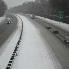
Snow in the United States

The National Weather Service (NWS) issued a series of warnings ahead of a complex low pressure system located over the northern high plains. This phenomenon will cause extreme weather conditions, including strong winds and snowfall in the Upper Great Lakes region beginning Thursday night.
Heavy snow and gusty winds across the Great Lakes
A severe winter storm is expected, bringing snow accumulations of four to eight inches. The impact will be compounded by wind gusts that could reach speeds of 70 to 80 miles per hour (110 to 130 kilometers per hour).
Before nightfall, some areas of the Northern Plains could experience a weather transition with a mix of snow and rain, impacting visibility and traffic on the roads.
Critical fire risk and conditions in the Plains
The same low pressure system will spread very strong winds from the Rocky Mountains eastward. Due to the combination of heat and low humidity, the Storm Prediction Center has declared a Critical Fire Hazard in the following areas:
- Parts of the central High Plains.
- Sectors of the southern Plains.
By Friday, the system is expected to move northeastward, with moderate snow chances in upstate New York and northern New England.
Atmospheric river in the Pacific Northwest
An active atmospheric river pattern will impact the Pacific Northwest and northern Rocky Mountains over the next several days, bringing with it:
- Heavy rains in low-lying areas with isolated flooding risks.
- Snow accumulations of several feet at high elevations.
- Blizzard warnings due to sustained high winds.
Although cold air on Friday could bring snow to lower elevations, both rain and snow are expected to begin to taper off during the day on Saturday.
Thermal contrast: record temperatures in the Southwest
- Southern California and desert Southwest: Highs up to 90 °F, with potential to break all-time records.
- Pacific Northwest (behind the cold front): Much cooler temperatures, ranging between 39 °F and 48 °F.
In the central and eastern part of the country, variability will be the norm. While the Mississippi Valley and East Coast experience cool highs today, cold air will settle over the Great Lakes on Friday, leaving warm temperatures only in the southern Ohio Plains and valleys.
LATEST