Pre-Christmas storms: High winds, snow and fire hazards as millions of Americans prepare to travel
The NWS activated high alerts in the central and eastern parts of the country for hurricane force gusts to wildfires ahead of the weekend.

File image of high winds.

The weather outlook is getting more complicated on the eve of the holidays. The National Weather Service (NWS) has issued critical warnings due to a powerful storm that, after battering the center of the country with high winds and blizzards, is now moving into the Great Lakes and Northeast.
This frontal system will bring strong gusts of wind and rain that, due to the drop in temperature, will quickly turn into snow showers on Friday, kicking off the two weeks when the most Americans travel each year. AAA estimates that more than 112 million Americans will travel between Dec. 20 and Jan. 1.
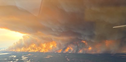
Extreme wildfire risk in Colorado and Wyoming
Despite the approach of winter, a destructive windstorm is generating "extremely critical" conditions for the spread of wildfires in the states of Colorado and Wyoming.
As of this Friday, the following risk factors are expected:
- Dangerous wind gusts: winds whose speeds will exceed 100 miles per hour.
- Warm temperatures: the thermometer will reach 70 degrees Fahrenheit.
- Atmospheric dryness: relative humidity levels to drop to 10%.
Wind progression will begin in the morning over the peaks and ridges, extending into the foothills during the afternoon and reaching the plains in the evening.
"Use caution with any potential ignition sources. Stay aware and follow instructions from emergency officials," the NWS emphasized.
High wind warning on both coasts
Weather instability is not limited to the center of the country. Moisture from the Pacific Ocean will continue to impact the West with persistent rain and significant snow accumulations in the mountain ranges.
On the other hand, a intense cold front is advancing from the east coast. This system will cause:
- Strong precipitation and wind gusts
- Lake-effect snow, drastically reducing visibility.

High wind response guide: Notice, watch and warning
In the event of a High Wind Warning, act now!
- Seeking shelter: stay inside a solid building.
- Road safety: if you must drive, slow down and hold the steering wheel with both hands.
- Avoid hazards: stay away from trees, light poles and metal structures.
Be prepared for a High Wind Watch.
- Secure your property: stow or secure patio furniture, trash cans, and any loose objects that could become projectiles when blown by the wind.
- Plan: adjust your travel to avoid being out in the elements during a storm.
In the event of a Wind Advisory, use caution.
- Although this is the lowest level of urgency, stay informed. Secure light objects and use extreme caution when driving over bridges or open areas.
Transportation complications: One of the busiest days of the year
The timing of these storms couldn't be worse for national logistics. According to the Aeronautical Weather Center (NWS AWC), this Friday is expected to be one of the highest-volume travel days in the United States.
"Tomorrow is ramping up to be one of the busiest travel days across the US! Various aviation hazards will impact portions of the West, Great Lakes, and New England regions," the agency warned.
Passengers are advised to check updated conditions on the AWC interactive map before heading to airports.
Storms before Christmas: How to adapt your travel plans?
In the face of NWS warnings, it is critical to prioritize safety. If your plans include road travel in Wyoming or Colorado, take precautions. For those traveling northeastward, be prepared for an abrupt transition from rain to snow that could freeze road surfaces.

Society
Storms before Christmas: How to adapt your travel plans in the face of NWS warnings
Santiago Ospital
LATEST