Storms before Christmas: How to adapt your travel plans in the face of NWS warnings
Find updated forecasts, high-risk areas and keys to interpreting weather warnings that may affect your travel plans.

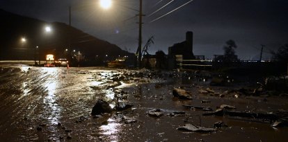
Severe blizzards threaten holiday travel

With Christmas just days away, the National Weather Service (NWS) has issued an urgent warning about a "powerful storm" that could jeopardize the plans of millions of travelers. This winter system, which will affect the northern part of the country, will bring dangerous wind gusts and heavy snowfall just ahead of the busiest travel days of the year.
Where will there be adverse weather?
For this Thursday, at the height of the holiday commute, the forecast calls for wind gusts between 50 to 80 miles per hour. These conditions will affect routes through the central Rocky Mountains and northern plains.
"Expect numerous power outages, property damage and dangerous travel. High wind warnings are in effect for these areas," the NWS warned. These outages could affect not only homes, but also transportation infrastructure and gas stations on key routes.
The northern plains will also receive snowfall by nightfall that, along with high winds, will complicate visibility. The blizzard will make taking the wheel "extremely hazardous."
Blizzard warnings are also in effect for parts of northeastern Montana and Minnesota, as well as much of North Dakota.
The storm system will move eastward. During its track, the Northeast may experience gusty winds of up to 60 miles per hour. They will be accompanied by heavy rain and snow.

Society
What are the hazardous wind gust warnings and what areas will be affected?
Virginia Martínez
Road safety: Prepare your vehicle
These extreme conditions will make travel difficult. If you must drive, check warnings from the NWS and local authorities before setting out on your trip. Be aware of the forecast at the various stops along your route at the time you estimate you will be at each, especially at the destination.
Once behind the wheel, extend caution when driving over bridges or open areas. Slow down and hold the steering wheel with both hands. Keep your distance from the car in front of you, so you have more time for emergency braking.
It is advisable to check the condition of your car before going out on the road. The authorities also recommend carrying an emergency kit:
- A flashlight
- Spare batteries
- Non-perishable, high-calorie food
- Food
- Water
- Food with a high calorie content
- Bottled water
- A phone charger
- At least one extra change of clothing
- Blankets
- Jumper cables
- Matches or a lighter
- A shovel or ice scraper
- Rough material (sandbags), in case your vehicle gets stuck in the snow
If you have a road emergency, authorities recommend:
- Stay in your car.
- Make your car visible.
- Put bright lights on the antenna or windows and keep the interior roof light on.
- Beware of carbon monoxide poisoning. Make sure the exhaust pipe is clear of snow and start the car only sporadically, just long enough to keep warm.
- Do not drive the car for long periods with the windows up or in an enclosed space.
More recommendations can be found at the Department of Transportation's official website.
Check live updates
The Aeronautical Weather Center (NWS AWC) warned of "several hazards expected across the country tomorrow" for this Thursday.
Warnings range from ice in Seattle to visibility problems in Charlotte, N.C., to high winds and turbulence in Minneapolis.
You can check updated travel conditions at the AWC's interactive map.
Understanding NWS high wind warnings
Wind Advisory:
- Issued when: high winds are present that do not reach destructive levels but are hazardous.
- Criteria: Sustained winds of 30-40 miles per hour or gusts of 45-60 miles per hour.
High Wind Watch:
- Issued when: there is a possibility of high winds in the near future (24 to 48 hours).
- Criteria: Sustained winds of 40 miles per hour or gusts of 60 miles per hour or higher.
High Wind Warning:
- When issued: when the event is imminent or already occurring.
- Criteria: Winds of 40 miles per hour or gusts above 60 miles per hour. This is the maximum alert level.
What is a winter storm warning, and what about an ice storm?
A winter storm warning means that heavy snowfall is expected.
- It can mean at least 6 inches fall in 12 hours, or at least 8 inches in 24 hours. It may also be issued if a sleet accumulation of at least 0.5 inches is expected.
- A winter storm warning means that there is at least an 80% chance of impactful winter weather conditions during the warning period.
An ice storm warning means that ice accumulation equal to or greater than 1.4 inches are expected.
- Ice accumulation can be dangerous for a variety of reasons: from bringing down structures such as power poles and trees to disrupting services such as power, to skidding cars on the road.
- Other hazards from ice storms include black ice (patchy layers of ice on roads or other transportation surfaces that are virtually invisible) and ice jams (freezing of rivers and lakes).
You can check the latest winter storm and ice storm warnings at NOAA's official website. In addition, experts recommend keeping an eye on alerts from the corresponding local branch of the NWS.
LATEST