Hurricane Erin: Authorities issue evacuation orders and ask to avoid beaches in North Carolina
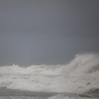
The Category 2 storm will hit the East Coast with heavy rain, high surf, and flooding, experts warn. Even before its arrival, the state emergency service reported that “numerous rescues” had already been carried out at sea.

GeoColor image of Hurricane Erin

Although Hurricane Erin continued to lose strength Tuesday, it continues to threaten the country's east coast with dangerous flooding. Its strong winds, storm surge and rain will begin Wednesday, as forecast.
"Swells generated by Erin will affect the Bahamas, Bermuda, the east coast of the United States, and Atlantic Canada during the next several days," the National Hurricane Center (NHC) warned Wednesday. "These rough ocean conditions are expected to cause life-threatening surf and rip currents."
"Tropical storm conditions are expected over portions of the North Carolina Outer Banks beginning late today or tonight," warned the NHC.
The islands may also experience heavy rainfall, up to 2 inches (5 cm), through Thursday. Thereafter, adverse conditions may also be experienced in areas north of Duck, North Carolina, as far north as Cape Charles Light, Virginia.
After reaching Category 5 over the weekend, the highest on the Saffir-Simpson scale, Erin was downgraded to Category 2. Although the eye of the hurricane is forecast to remain far from the mainland, forecasters remain concerned about the magnitude of Erin, which is advancing with strong winds hundreds of miles beyond the storm's core.
As it passed through Puerto Rico, it left thousands of homes without power and homes and roads submerged by water.
Evacuation orders, beach closings
In preparation for its arrival, coastal communities in North Carolina issued evacuation orders. Authorities asked those in surrounding areas to prepare, in case they received similar indications.
"Now is the time to make final preparations, secure property, and evacuate with all personal belongings," they warned from Hyde County over the weekend, by issuing a state of emergency.
"Dangerous waves, 20+ feet, will likely inundate and destroy protective dune structures along the highway. Portions of Highway 12 on Ocracoke and Hatteras Islands will likely be impassable for several days. Life-threatening swimming and surfing conditions are expected. Rip current risks will be extremely high! Stay out of the water!"
Hours later they followed suit in Dare County, accompanying the emergency declaration with evacuation orders:
At the state level, Governor Phil Murphy extended the calls for caution up and down the coast: "Please avoid swimming in the ocean, especially when lifeguards are not present. It is more important that you stay alive than get one more beach day before the end of summer."
Beaches across the state are closed. At Wrightsville Beach in New Hanover County, they have been recommending avoiding the ocean since Tuesday. "These swells are producing powerful rip currents that can create extremely hazardous swimming conditions," warned local rescue director Sam Proffitt. The restrictions will remain in place until at least Friday.
"We already saw large numbers of rescues from rip currents along the North Carolina coast yesterday," Justin Graney of the state Emergency Management Service reported. "If you are vacationing along our beautiful beaches, please stay out of the water this week and make sure you are following instructions from local officials." Wrightsville Beach authorities, for example, claim to have rescued more than 60 beachgoers on Monday.
Stronger than normal season
The NHC is monitoring two disturbances following Erin: the first has a 60% chance of becoming a cyclone over the next week, and the second, a 30% chance.
Society
Hurricane season 2025: Protecting your home and building the ultimate survival kit
Santiago Ospital
LATEST