Heavy rain, severe storms and extreme temperatures will mark the start of summer
Two frontal systems will move across the central and eastern parts of the country over the next 48 hours. On Monday, there is a chance of heavy rain and severe weather from New York to Wyoming, fueled by a warm, humid and unstable air mass.

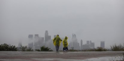
Rain in California

The start of summer will be accompanied by active weather across large parts of the country, with a risk of heavy rain, severe storms and temperatures significantly higher than usual, the National Weather Service’s Weather Prediction Center (WPC) reported on Monday.
According to the forecast, two frontal systems will move across the central and eastern parts of the country over the next 48 hours. On Monday, there is a chance of heavy rain and severe weather from New York to Wyoming, fueled by a warm, humid and unstable air mass.
Although the advance of a cold front will reduce the risk of storms and heavy rain in the eastern part of the country by Tuesday, unstable conditions will persist in the central part of the country through the middle of the week, with daily chances of flash flooding and scattered severe storms.
At the same time, the first full days of summer in 2026 will bring well-above-average temperatures to much of the western United States, including the West Coast, the Great Basin, the Southwest, and the Rocky Mountains. The heat will also extend into Texas, the Gulf Coast, the Southeast and Florida.
Heat alert
Heat advisories remain in effect in the Pacific Northwest and the Southern Plains, where more than 21 million people remain under weather advisories.
In contrast, the northern and central plains, the Great Lakes region and the Northeast will see below-average temperatures over the next few days.
LATEST