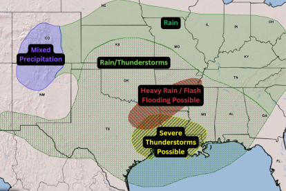
Southern storm: Map of areas at risk of flooding and thunderstorms
Tornado and flash flood warnings for Texas, Louisiana and Mississippi: what you should know for the next few hours.

Texas will be one of the states hardest hit by precipitation

The National Weather Service (NWS) issued a warning for a powerful storm set to impact the southern part of the country this Saturday. The forecast includes fierce rainfall, severe thunderstorms and threats of flash flooding in multiple states.
The storm system will initially hit the southern plains this Saturday, moving rapidly. Areas under heightened alert are:
- Texas
- Louisiana
- Mississippi
In these states, in addition to precipitation, there is a Tornado Watch as the afternoon progresses, driven by the presence of strong winds at high altitude.
Map of areas under risk:
Forecast Feb. 14
Forecast for Sunday
Overnight Saturday and early Sunday, the weather risk will move eastward, encompassing Alabama, Georgia and Florida.
"The trailing cold front will interact with lingering Gulf moisture, increasing chances for widespread showers and thunderstorms stretching into the Southeast," the NWS said.
The Weather Prediction Center (WPC) stressed that heavy rains will generate a threat of flash floods. Given this scenario, authorities recommend:
- Stay informed: Follow constant weather updates in your area.
- Active alerts: Have multiple avenues to receive emergency notifications (radio, apps, presidential alerts).
- Road safety: NEVER drive or walk on a flooded road. The slogan is clear: "Turn Around, Don't Drown."
California snow alert: Historic snowfall in the Sierra Nevada
The Sierra Nevada is expected to record several feet of snowfall, leading to significantly reduced visibility and major travel delays during the first half of next week.
- Sunday: Onset of heavy snowfall in the northern California mountain ranges.
- Monday: Storm expansion into the Sierra Nevada and southern ranges.
- Accumulation forecast: 4-8 feet of snow estimated at higher elevations through Wednesday.
Authorities warn that driving conditions will be hazardous or even impossible at various mountain passes, including critical points on I-80.
LATEST