


Half the country on alert: "massive winter storm" wreaks havoc from coast to coast
Record lows are being reached in several states. Flights have been canceled, roads are closed and people are without power. Los Angeles will experience snowfall conditions not seen in 30 years.
Historic records: ""massive winter storm"" wreaks havoc from coast to coast.

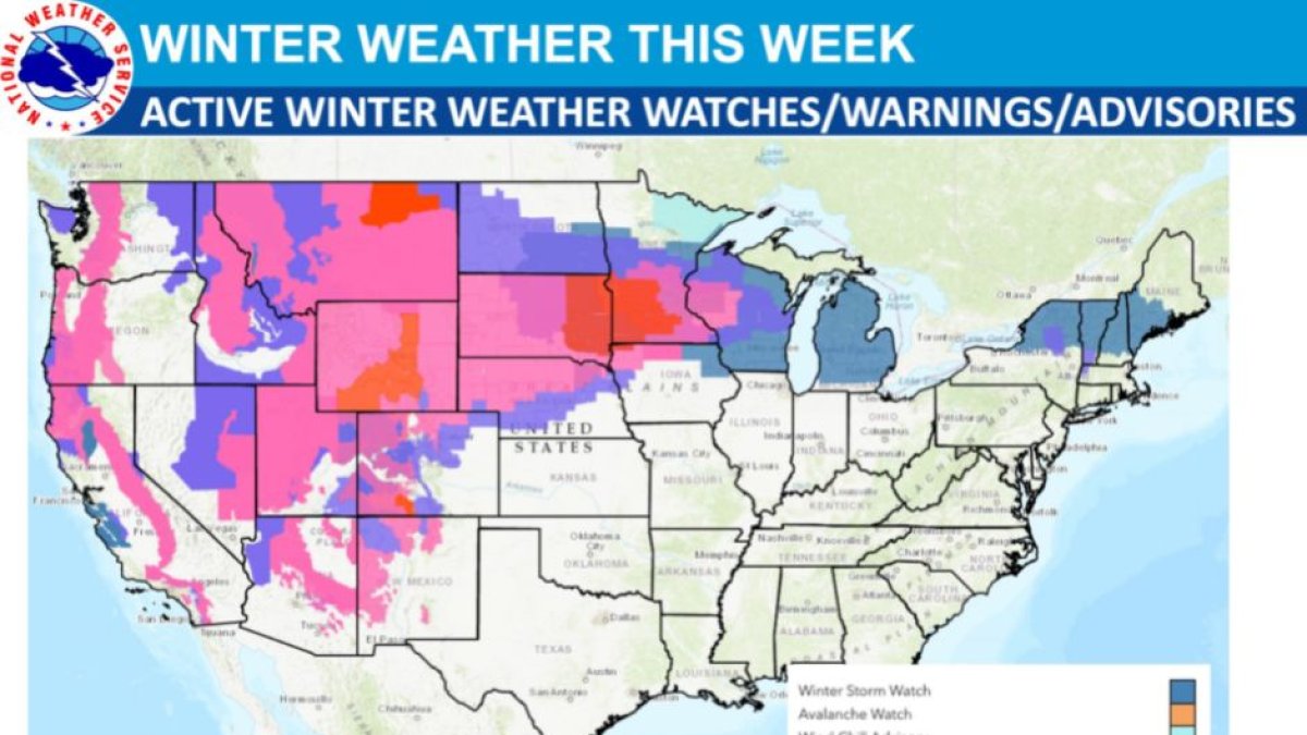
The National Weather Service (NWS) warned a few days ago about major winter storms that would sweep "from coast to coast" and bring historic snowfall and excessive rainfall.
More than 65 million people in 29 states are on alert due to the storm. All-time records were broken for temperatures in cities in the Midwest, Mid-Atlantic and Southeast.
These extreme conditions significantly impact the lives and mobility of citizens: interstate highways have already been closed from Arizona to Wyoming, where hundreds of drivers have been stranded in their vehicles, thousands of people have been without power, and nearly 7,000 flights have been canceled or delayed.
Weather conditions not seen in 30 years
The NWS warned that the "massive winter storm" would spread across the country for approximately seven days. Its latest update added a forecast for an additional six to 12 inches of snow, rain and "very strong winds" of up to 50 mph (80 km/h) "in the West and adjacent High Plains."
In the north, a region accustomed to snowfall, 15 to 25 inches of snow are expected. Parts of Minnesota and Wisconsin will be the hardest hit.
Southwest Oregon, southern Nevada, and California will also be hit, specifically the Sierra Nevada, Great Basin and Four Corners regions. These areas are expected to accumulate three to five inches of snow. Los Angeles is preparing for snowfall conditions not seen in 30 years.
Daniel Swain, a climate scientist at the University of California, Los Angeles (UCLA) wrote on Twitter:
The latest NWS forecast noted that up to a half-inch of snow is expected in places on the Pacific Coast "where snowfall is less common":
On the other hand, more than 653,000 residents in Michigan, nearly 150,000 in California, 98,000 in Illinois, 48,000 in Wisconsin, 30,000 in New York and 12,000 in Indiana were without power Wednesday night.
The effects of the winter storms will continue through next Saturday, according to forecasts.
Extreme heat on the east coast
In contrast, new record high temperatures were recorded on the east coast, especially in some cities in the Mid-Atlantic and Southeast.
In both South Carolina and North Carolina, highs ranged from 80ºF to 90ºF. Indianapolis; Cincinnati; Washington; Atlanta; Mobile, Ala.; and some cities in Florida were among the many other places where significant highs were recorded.
Record highs were broken in Lexington, Ky., reaching 76ºF, surpassing the previous Feb. 22 high of 70ºF recorded 101 years ago. In Nashville, Tenn., temperatures reached 80ºF, beating the 1897 record by 4 degrees.
"We could see records everywhere from Pittsburgh to as far south as Fort Myers, Fla.," noted NWS meteorologist Frank Pereira.
LATEST