New wave of tornadoes: Map of states at risk and recommendations for survival
After the tragic toll of eight dead in Michigan and Oklahoma, meteorologists warn of powerful winds, flooding and hail this Wednesday.
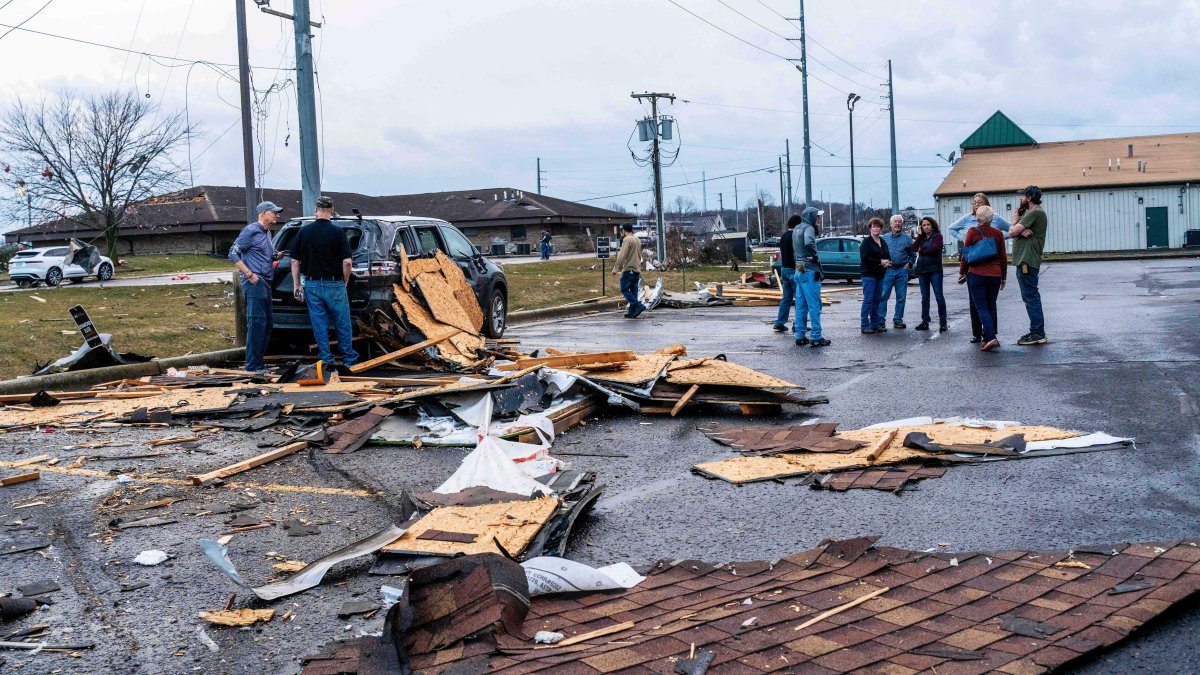
Tornado in Michigan on March 6

Just days after a series of tornadoes left a tragic toll of eight dead in Oklahoma and Michigan, meteorologists are issuing a new and troubling warning. A massive storm system threatens to unleash a new wave of intense tornadoes, hail and flash flooding in the central and eastern parts of the country.
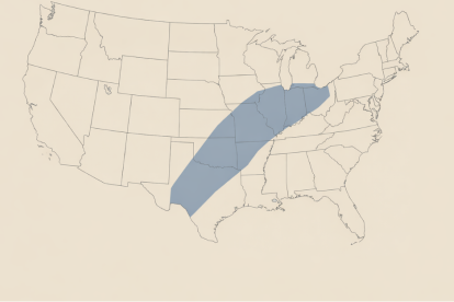
The Storm Prediction Center (SPC) has indicated that the impact area for Wednesday extends from the southern plains to the southern Great Lakes area. According to Adam Douty, a meteorologist with AccuWeather, this event has the potential to become "the largest outbreak of severe weather so far this year."
In addition to wind, rain will be a critical factor. Heavy rainfall is expected and could cause flash flooding in a corridor stretching from central Texas to southern Michigan.
Map: States under Tornado Watch
Nine states should maintain the highest guard this Wednesday:
- Texas and Oklahoma
- Arkansas and Missouri
- Illinois and Indiana
- Kentucky and Tennessee
- Michigan
Large urban centers with high Hispanic populations, such as Dallas, Chicago, St. Louis, Oklahoma City, Indianapolis and Kansas City, could be immersed in powerful thunderstorms capable of generating significant damage.
Tornado Risk
Wednesday's storm moves through
The National Weather Service (NWS) warns that the storm will move eastward, reaching areas of Pensylvania and New York. Although a "Slight Risk" (level 2/5) has been established for some areas, the danger of damaging winds and focused tornadoes remains high in the Upper Ohio Valley and from eastern Texas to the Lower Mississippi.
Survival Guide: What to do in a tornado?
1. In homes and public buildings
- Find the lowest point: Head for the basement or a small interior room (bathroom, closet or hallway) on the lowest level.
- Put up barriers: Put as many walls as possible between you and the outside. Stay away from windows at all costs!
- Protect your head: Use bike helmets, heavy blankets, coats or pillows to protect yourself from flying debris.
2. In mobile homes
- Evacuate early: Do not stay in a mobile home. Head for a nearby solid shelter. If there isn't one, find a ditch or low-lying area and cover your head with your hands.
3. If you are in your vehicle or outdoors
- Do not use bridges: Never take shelter under a highway overpass; wind can accelerate there due to the "tunnel effect" and be deadly.
- Seeking shelter: If you can't reach a building, stay in the car with your seatbelt on and your head covered, or seek a low area on the ground.
4. Don't waste time
- Don't waste valuable seconds opening or closing windows to "balance the pressure." That won't save the structure and will expose you to greater risks.
- Important note: Keep your phone charged and tune in to local news or a NOAA weather radio. Real-time information is your best defense tool.
A tragic week: Record destruction in Michigan and Oklahoma
Between March 5 and 7, a series of devastating storms generated at least 13 tornadoes in the center of the country, leaving eight dead and 26 injured.
The state of Michigan experienced a historic and fateful day on March 6: four tornadoes touched down, including an EF-3 with winds of 160 miles per hour. This phenomenon was not only the earliest EF-3 category tornado in the state's history (surpassing the March 2012 record), but made that day the deadliest by tornadoes in Michigan in the last 46 years.
In addition to the casualties in Michigan, the state of Oklahoma reported four fatalities, while additional tornadoes were documented in Arkansas, Texas and Kentucky, underscoring the danger of this weather system that is now threatening to return.
LATEST