ANALYSIS.
How did the Texas flood tragedy come to pass?
What happened in the Lone Star State reflects the "worst-case scenario," according to experts. A lethal and almost impossible combination of geographical and climatic factors, compounded by the critical timing of when the disaster struck.

Members of the rescue services prepare a boat.

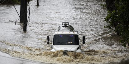
How could this tragedy have happened? Five days after the start of the floods that have left more than 100 dead—a figure that continues to grow—and a region devastated by water, is the question that millions of people continue to ask themselves. The answer lies in a combination of natural, geographical and atmospheric factors, but it also points to failures in the alert system in the area hardest hit by one of the worst disasters the country has seen in recent years.
First of all, it should be noted that what happened in the Lone Star State reflects the "worst-case scenario," according to experts. A lethal and nearly impossible combination that caused the Guadalupe River to reach points where it had barely a 1% chance of reaching for it to be a major disaster and a 0.2% chance of reaching the magnitude it eventually did.
An area known as "flash flood alley"
Geography is a key factor in explaining the tragedy. In conversations with AFP, Hatim Sharif, a hydrologist at the University of Texas at San Antonio, explained that, not for nothing, the Hill Country region is located in an area known as "flash flood alley."
According to the expert, "the warm air from the gulf rushes up the Balcones escarpment—a line of steep hills and cliffs that arcs southwestward from Dallas—cools and pours torrents over thin soils that quickly give way to bedrock. The runoff is then channeled through a dense network of streams."
The water level shot up in a matter of minutes
This causes “the water to rise very, very quickly, in a matter of minutes or hours,” explained Sharif. Tragically, the events of the early morning of July 4 proved him right.
The U.S. National Weather Service (NWS), issued a flood warning shortly after 01:00 am, but most campers were sleeping. Phones were banned and coverage was spotty, while darkness made escape routes difficult to define.
About 03:00 am local, a gauge near Camp Mystic, in Hunt, indicated that the Guadalupe River was rising nearly 30 centimeters every five minutes. Shortly thereafter, at 04:30 the level of the tributary rose more than 6 meters, according to NWS data. An amount of water sufficient to sweep away people, vehicles and buildings.
According to Sharif, these circumstances make it advisable to start using hydrological forecasts that convert precipitation into probable river levels. "Precipitation should translate into runoff," he says. "If you have 25 centimeters, what's going to happen."
Summer camps have long attracted visitors to the region for its natural beauty. But with increasing risks, Sharif warns that it is unwise to treat these sites as safe or permanent.
In background: Ten flood deaths in 1987 in the same area
Ten teenagers lost their lives on that occasion, when a bus and van fleeing the camp were engulfed by floodwaters. Rescue services managed to save 33 others were who managed to cling to treetops.
The region's hot climate, exacerbated by drought
Climate is another key point in explaining the disaster. A warmer atmosphere—such as that caused by the drought Kerr County has been suffering since early 2025—retains more moisture, which favors downpours. Experts point out that areas suffering from drought are more susceptible to flash floods, since the soil does not have the capacity to absorb precipitation effectively, compared to other situations. Coupled with the rocky topography of the area, the risk of flooding was vastly increased.
"The landscape was probably quite dry, and everything that fell was probably running off quite rapidly, in the same way that water would run off on a paved surface," Marshall Shepperd, director of the University of Georgia's Atmospheric Sciences Program and former president of the American Meteorological Society told ABC News.
Gulf wetlands and remnants of tropical storm Barry
Adding to that was an abundance of tropical moisture from the Gulf, which was joined by monsoon humidity from the eastern Pacific and the remnants of Tropical Storm Barry, which made landfall on the east coast of Mexico on June 29, Shepperd said.
Although Barry dissipated quickly on its way inland, its residual circulation continued its stealthy path northward toward the Texas-Mexico border, carrying with it some tropical moisture from the Bay of Campeche to the Lone Star State. The extremely high level of atmospheric moisture over the region provided ample fuel for persistent torrential rains and extreme precipitation.
The atmospheric conditions prevailing at the time disaster struck over the southern plains favored the formation of slow-moving thunderstorms discharging their rain over the same area for extended periods of time, which markedly increased the likelihood of flash flooding.
Extraordinary rainfall, "a disaster waiting to happen"
And this brings us to the last—though by no means least—factor, which was in fact the trigger: the "extraordinary" rainfall over the area, which ultimately set off the meteorological bomb.
According to the NWS, "extraordinary precipitation rates" of between 5 and 10 cm per hour in some areas, such as Kerr and Mason counties, equate to as much as 45 cm at some points. "That volume of water falling over relatively short periods of time, that's a disaster waiting to happen," Shepperd corroborated.
The NWS began warning of heavy rains four days earlier
After the analysis of natural phenomena, the human factor remains to be seen. And all eyes now turn to the warning system and communication of the agencies in charge of monitoring weather phenomena and alerting the population if necessary. One point that favored the high death toll is that the most serious events were triggered in the early hours of Friday morning, when many of the victims were asleep and either could not heed the warnings or their ability to react was diminished by sleep.
In this regard, Shepperd shared on his Facebook account a post detailing the evolution of the NWS warnings through several of its branches. The agency's first advisory came on June 30, when it issued a heavy rainfall warning between July 3 and July 7.
On July 2, the Texas Division of Emergency Management (TDEM) issued a communication reporting that the agency "activated state emergency response resources in anticipation of increased flood threats in some areas of West and Central Texas."
In parallel, the National Oceanic and Atmospheric Administration included the risk of flash flooding in its hazard forecast for the next three to seven days. These types of warnings, including the flash flood emergency (the highest flash flood warning), are distributed by the NWS in the same manner as tornado warnings: through the national EAS and WEA warning systems.
Warning systems under debate
As reported by AFP, in Kerr County, the informal practice of summer camp staff communicating by radio and alerting other shelters continues. An initiative that presents obvious risks and that the commissioners themselves considered replacing with a siren alert system.
However, it was considered "a bit extravagant" and they opted to continue with the current model. In fact, as recorded in a transcript of a 2015 meeting minutes, commissioner H.A. Buster Baldwin noted that "the idea of our beautiful Kerr County having these damn sirens going off in the middle of the night is going to force me to go back to drinking so I can resist."
"Five minutes of that siren could have saved every one of those kids," staff at one summer camp told AFP to radio and alert other shelters.
Experts and the NWS insist on the use of NOAA weather radio
The NWS again stressed the need for campers, and especially camp managers, to have a NOAA All Hazards weather radio. These are battery-operated devices that offer more reliable coverage throughout the country than cell phone service, making them a reliable and established alternative.
Through these devices, one can tune into NWR, a nationwide network of radio stations that broadcast continuous weather information directly from the nearest NWS office. It broadcasts official Weather Service advisories, warnings, forecasts and other hazard information 24 hours a day, seven days a week.
According to ABC News weather correspondent Ginger Zee, this device "will wake you from a dead sleep. Timely alerts from the National Weather Service (NWS) that night can be programmed to go off and wake people up, giving them at least a few minutes, if not more, to seek higher ground."
LATEST